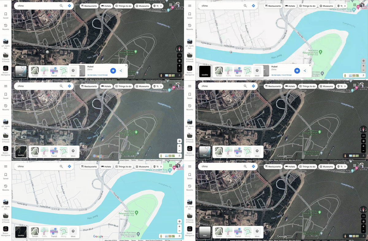
My recent series of posts showcases issues I've frequently discussed in my professional work that are seemingly obscure outside the geography community. This post addresses the Chinese offset on maps. I have had many conversations about this issue because the map products I work with are specific to the security and intelligence communities. But it affects all maps of China.

If you watch the GIF above you'll see the satellite image is shifted from the street map. What's happening here? The Surveying and Mapping Law of the People's Republic of China of 2013 [1] restricts map content, even within China. Specifically, China enforces the use of a map projection (I talked about projections a few weeks ago) called GCJ-02 [2], but colloquially referred to as the Mars projection. This projection intentionally obfuscates the geographic information by utilizing an algorithm that randomly misaligns a coordinate up to 700 meters in any cardinal direction. [3, 4, 5, 6] Only approved, licensed users have access to an encryption that clears the obfuscation [7].
Most commercial, digital map solutions utilize the WGS 84 projection, which includes the coordinates of the features being plotted on the map. As a product manager, you must be aware these features will intentionally not align with a GCJ-02 basemap.
Best practices
Here are some suggestions for addressing the Chinese offset in your mapping products:
When available, use an open-source map solution, if allowable, as the basemap when displaying and searching for map features
- OpenStreetMap (OSM)’s legal section explains the entire project is considered illegal in China and therefore does not show the offset on their maps
- If the open-source map utilizes basemaps from a commercial product they will still be offset
If an open source map is not available, utilize a satellite or hybrid satellite basemap for displaying and searching for map features
- It is less feasible to stretch the imagery beyond recognition in various directions so it is usually offset slightly to perform the misalignment
- Don’t flip between basemaps – you’ll only get more frustrated they don’t align
When using geofences to search for precise coordinates:
- Create the geofences larger than anticipated, at least by a few hundred meters
- Be willing to do a follow-up search as a refinement once you’ve identified the actual area of interest

End Notes
1. National Administration of Surveying, Mapping and Geoinformation of China (NASG)’s Surveying and Mapping Law of the People Republic of China. 2013/12/23 https://web.archive.org/web/20171113214606/http:/en.nasg.gov.cn:80/lawsandregulations/201312/t20131223_93546.shtml
2. Wikipedia’s Restrictions on geographic data in China section on GCJ-02 https://en.wikipedia.org/wiki/Restrictions_on_geographic_data_in_China#GCJ-02
3. Chinese street maps out of alignment in Google Earth and Google Maps https://www.gearthblog.com/blog/archives/2015/08/chinese-street-maps-alignment-google-earth-google-maps.html
4. A More Complete iOS Solution to the China GPS Offset Problem https://www.sinosplice.com/life/archives/2013/07/16/a-more-complete-ios-solution-to-the-china-gps-offset-problem
5. Why is China messing with our GPS coordinates? https://geoawesomeness.com/eo-hub/china-messing-gps-coordinates/
6. Restrictions on Geographic Data in China https://encyclopedia.pub/entry/36454
7. Restrictions on geographic data in China https://en.wikipedia.org/wiki/Restrictions_on_geographic_data_in_China
Find out how to transform your data into actionable insights.
Schedule a DemoStay Informed
Sign up to receive the latest intel, news and updates from Babel Street.


